RSS

Ambleside’s Future Comes into Focus with Final Acquisition for Waterfront Park Plan

West Vancouver celebrates a milestone as the last private home along Ambleside’s waterfront is acquired, clearing the way for a fully connected public shoreline.

After nearly five decades of patient planning, steady land acquisition, and extensive public consultation, the District of West Vancouver has reached a historic turning point in the realization of its ambitious Ambleside Waterfront Concept Plan. On March 31, 2025, Mayor Mark Sager and Council announced the final purchase in a string of 32 properties stretching from 13th to 18th Streets—a move that cements the district’s vision for a fully public, accessible, and integrated waterfront.

This final acquisition, the former home at 1444 Argyle Avenue, will be deconstructed in fall 2025, clearing the last physical barrier between John Lawson Park and Ambleside Green. The area will become part of Brissenden Waterfront Park, forming a continuous ribbon of open green space designed to connect the community not just to the shoreline—but to each other.


A Waterfront for Everyone: Key Features of the Concept Plan

At the heart of the Ambleside Waterfront Concept Plan is the principle of increasing public access, enjoyment, and ecological stewardship along this prized stretch of shoreline. Initially endorsed in June 2016, the plan outlines a bold yet community-centered vision for revitalizing West Vancouver’s waterfront with a focus on recreation, arts, environmental sustainability, and cultural heritage.

A Seamless Shoreline Experience

The plan introduces two main east-west corridors: a pedestrian-only seawalk and the Spirit Trail, a shared bike and pedestrian path. These linear connections aim to link Ambleside, Park Royal, and Dundarave while enhancing safety and accessibility. The continuous foreshore path meanders naturally through the landscape, offering a more tranquil and immersive waterfront experience.

Green Spaces and Gathering Places

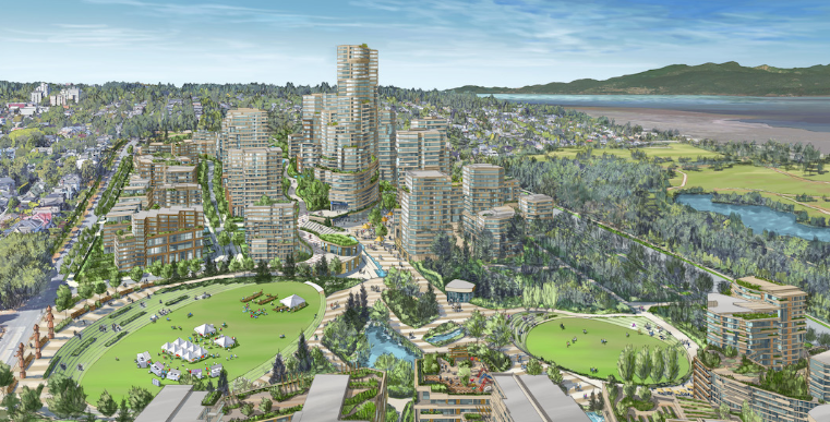
Once completed, the waterfront will feature an interconnected park system uniting John Lawson Park, Millennium Park, Ambleside Green, and the emerging Brissenden Waterfront Park. These parks will be designed for both passive reflection and active recreation, incorporating event-friendly plazas, a new stage in John Lawson Park, and distinct zones like Heritage Plaza and Arts Plaza at key street ends.

*Photo by City of West Vancouver


Honouring Heritage and the Arts

The plan also makes room for West Vancouver’s rich cultural and natural heritage. The historic Ferry Building Gallery will remain a fixture, complemented by a new Community Arts Building and upgraded facilities for arts education. Meanwhile, Navvy Jack House—one of the region’s oldest homes—is being reimagined as a community-based nature centre, anchoring the western end of the waterfront.

The Silk Purse and Music Box will be removed to make way for more modern, functional arts programming buildings. These changes underscore a commitment to preserving history while modernizing infrastructure to meet evolving community needs.


Enhancing Connection and Activation

Efforts to better integrate Ambleside’s commercial precinct and waterfront include festival street designs for 14th and 17th Streets, improved north-south pedestrian connections, and carefully designed signage. The expanded piers at 14th and 17th Streets will support everything from water taxis and boat moorage to community events and contemplative recreation.

A thoughtfully scaled commercial component adds vibrancy: from seaside bistros and food trucks to boat rentals near the Hollyburn Sailing Club, the plan offers a fine balance of leisure and lifestyle.


A Legacy of Stewardship and Patience

The transformation of Ambleside’s waterfront has been decades in the making. The Argyle Acquisition Policy, dating back to 1975, laid the groundwork for converting private waterfront properties into public parks. Key milestones include the removal of the Lawson Creek Studios in 2018, the extension of Millennium Park in 2021, and the opening of Brissenden Waterfront Park in 2024 following the relocation of the historic Jim Pattison home.

The recent 2025 acquisition of 1444 Argyle Avenue marks the final puzzle piece, fulfilling the community’s long-held goal of continuous public ownership along the waterfront.


What’s Next?

With all properties now under District ownership, attention turns to the final phases of implementation. Consultants continue working with parks staff, stakeholders, and community advisory groups to refine the remaining details. While the build-out will proceed in sections over several years, each step brings the vision closer to reality.

Curious how this will shape the future of Ambleside? We’re watching closely as the shoreline evolves—if you’d like to stay informed or discuss what this means for your property or investment plans, we’re here to help.

Read

North Vancouver’s $3.86B Wastewater Overhaul: Inside the North Shore Treatment Plant Transformation

A critical overhaul of North Vancouver’s wastewater infrastructure is now underway as Metro Vancouver pushes forward with the North Shore Wastewater Treatment Plant Program. Designed to replace the aging Lions Gate facility, this state-of-the-art project promises to improve wastewater treatment for more than 300,000 residents, while bringing modern environmental standards and public amenities to the community.

Though originally budgeted at $700 million in 2013, the project has since ballooned to an estimated $3.86 billion—fueling debate, drawing scrutiny, and placing it under the microscope of a newly launched independent performance audit. Here's a look at what’s being built, why it matters, and how it could reshape the future of North Vancouver’s waterfront and infrastructure.


Replacing an Outdated System: Why This Project Matters

The Lions Gate Wastewater Treatment Plant, tucked along the Burrard Inlet shoreline, has served the North Shore for 60 years—long beyond its prime. It currently offers only primary treatment, making it one of the last of its kind along the west coast of North America. As environmental standards evolve and population growth pressures the system, Metro Vancouver is stepping in to future-proof local infrastructure.

The new North Shore Wastewater Treatment Plant, located in the District of North Vancouver, will provide tertiary treatment—filtering out more contaminants before discharging treated water back into the inlet. It’s also being built to withstand seismic events and rising sea levels, ensuring long-term operational resilience.


A Compact, Community-Friendly Facility

The facility will adopt a vertically stacked, space-efficient design—a necessary innovation in a region where industrial land is scarce and expensive. Odour control, enclosed architecture, and public-facing features like a plaza and community meeting spaces are all baked into the design. In addition to boosting capacity, the new plant will aim for LEED Gold and ENVISION Gold certifications, reinforcing Metro Vancouver’s commitment to sustainability.

The adjacent Conveyance Project—already completed—adds roughly 3 km of new sewer pipes and includes the award-winning First Narrows Pump Station. Located under the Lions Gate Bridge, the station not only boosts wastewater transfer efficiency from West Vancouver but also integrates local art into its design, blending infrastructure with public realm enhancements.


Behind Schedule and Over Budget

Construction began in 2017, but the project faced major turbulence when Metro Vancouver terminated its contract with original builder Acciona in early 2022, citing significant deficiencies. Since then, the region has worked to reset the project with new leadership, hiring PCL as construction manager and AECOM to oversee design.

Project spending reached $831 million by March 2025—just over one-fifth of the newly approved $3.86 billion budget. Full completion is now expected in 2030, with decommissioning of the Lions Gate facility to follow thereafter. The Lions Gate site, leased from the Province, is expected to be returned and transferred to the Sḵwx̱wú7mesh Úxwumixw (Squamish Nation), in alignment with reconciliation objectives.


Cost Impacts for North Shore Residents

The rising price tag has direct implications for local households. Residents in the North Shore Sewerage Area—West Vancouver, District of North Vancouver, and City of North Vancouver—can expect average annual costs of approximately $590, phased in over five years. Other areas of Metro Vancouver will share a smaller portion of the financial burden, with costs ranging from $80 to $150 depending on location.

Municipalities determine how these costs are passed on to residents, whether through utility rates, property taxes, or a combination of both.


Building Through Challenges: Construction and Sustainability

On-site, activity is ramping up with construction crews pouring concrete, assembling formwork, installing steel structures, and prepping critical systems like the Influent Pump Station and digesters. Equipment procurement and re-negotiation with priority vendors remain ongoing, while coordination continues with utilities such as BC Hydro, Fortis, and TELUS.

Sustainability is a key driver: Metro Vancouver is managing wildlife impacts, reclaiming water, and ensuring environmental compliance with updated stormwater discharge protocols following a significant rain event in late 2024.


Public Oversight and Accountability

Public scrutiny intensified with the soaring costs, prompting Metro Vancouver to initiate an independent audit in 2024. The MWGK Independent Review Team, led by Peter Milburn, is now reviewing the entire program—from contractor selection and project governance to budgeting and scheduling.

Community outreach remains active, with newsletters, construction notifications, council updates, and liaison support ensuring residents stay informed. Metro Vancouver emphasizes that community input—especially from First Nations—has shaped the plant’s design and function from the beginning.


A Long Road Ahead

While progress continues steadily, the North Shore Wastewater Treatment Plant Program still has several years of construction, commissioning, and community adaptation ahead. It represents not just an engineering challenge, but a test of governance, regional cooperation, and long-term sustainability planning.

Curious how this transformation could reshape North Vancouver’s future? We’re tracking projects like this so our clients always stay one step ahead. Want to be one of them?

Read

Restoring West Vancouver’s Past: The Navvy Jack House Gets New Life as Bistro and Heritage Landmark

In the heart of Ambleside, one of the oldest homes in the Lower Mainland is undergoing a transformative revival. The Navvy Jack House, built in the 1870s and steeped in West Vancouver’s early settler and Indigenous history, is set to reopen not as a museum but as a vibrant, heritage-rich bistro and wine bar. With its restoration and redevelopment now in full swing, this iconic structure is poised to become a new gathering place along the shoreline—where history meets hospitality.


A Landmark with Layers of History

Perched at 1768 & 1770 Argyle Avenue, the Navvy Jack House occupies a prominent waterfront site adjacent to Lawson Creek. Its builder, John “Navvy Jack” Thomas, was a Welsh navy deserter who ferried people across Burrard Inlet and popularized the gravel mix that still bears his nickname. Constructed between 1872 and 1874, the home is believed to be the longest continuously occupied residence in the region.

Over the years, it also housed John Lawson, considered the "father" of West Vancouver. His tenure there and the home’s proximity to the water and Swy-Wee Lagoon (now a duck pond) underscore its historical, architectural, and ecological value.

Despite facing demolition in 2020, public advocacy from the Navvy Jack House Citizen Group convinced the District to reconsider. What followed was a comprehensive feasibility study and a professionally guided Heritage Conservation Plan that paved the way for its future as a cultural hub.


A Thoughtful Approach to Preservation and Use

The restoration project, led by Architectural Collective and developer Carrera Management Corporation, adheres to Parks Canada’s rigorous conservation standards. The approach emphasizes preservation, minimal intervention, and the careful replication of original features—from cedar siding to century-old floorboards. Where elements are missing or too deteriorated to repair, replacements will match the original in material and form.

Plans call for a 1,206 sq ft restoration of the original house and a 768 sq ft west-side addition, capped with a 624 sq ft patio space. The new bistro will accommodate up to 144 seats and feature a commercial kitchen, indoor dining space, and retractable patio walls. Though the structure will be raised to address coastal flooding concerns, it will remain on-site—maintaining its physical and cultural ties to the land.

Notably, the project incorporates Indigenous perspectives and artwork. Collaboration with the Musqueam, Squamish, and Tsleil-Waututh Nations will influence how the site reflects shared histories and recognizes traditional territory.


Navigating Permits, Community Input, and Environmental Stewardship

The project has cleared critical regulatory hurdles, including the Environmental and Foreshore Development Permits approved in December 2024. These approvals account for the site’s sensitive location near Lawson Creek and the ocean’s edge, integrating flood control and riparian protection into the design.

Community feedback, especially on issues like access and parking, was collected during the application process. Though these concerns were outside the development permit’s scope, they are being addressed through the lease agreement with the operator.

In terms of sustainability, the restoration aligns with national best practices for adaptive reuse, reducing construction waste and conserving the building's embodied energy. Landscaping by Prospect & Refuge enhances native plantings while protecting existing trees and ecological features.


A New Chapter at the Water’s Edge

The Navvy Jack House restoration marks more than just a heritage win—it’s a vision for how communities can preserve their past while creating inclusive, vibrant spaces for the future. Through the combined efforts of local government, passionate citizens, First Nations, and private investment, this former residence will soon serve coffee, wine, and a generous helping of West Vancouver’s rich history.

Curious how a 150-year-old home is becoming Ambleside’s newest waterfront destination? We’re following the Navvy Jack House transformation closely—because understanding where we’ve been shapes where we’re going. Want to stay in the loop on community-shaping projects like this one? We’d love to keep you informed.

Read

New Track and Field Hub at WVSS: West Vancouver Place for Sport Nears Completion

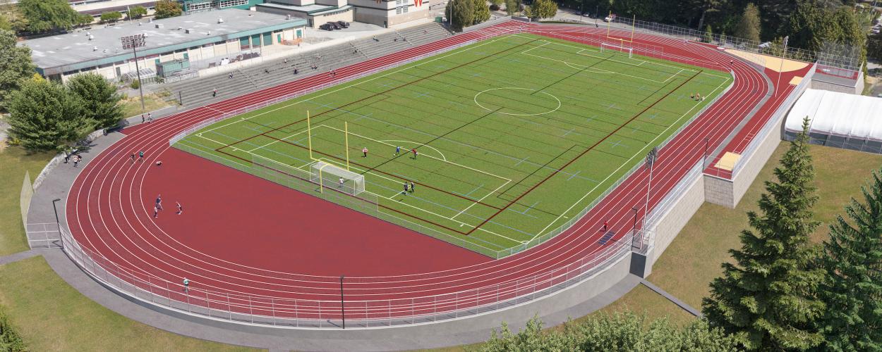
A long-awaited athletic facility is finally becoming reality in the heart of West Vancouver. The West Vancouver Place for Sport — a state-of-the-art track and field complex at West Vancouver Secondary School — is entering its final phase of construction and is expected to fully open by mid to late June 2025.

With the Harry Jerome Oval as its centrepiece, the new facility is set to serve students, athletes, and the broader community for years to come, transforming a previously aging and underperforming field into a vibrant sports destination.


A Vision Years in the Making

Plans to revitalize the aging sports field at West Vancouver Secondary School (WVSS) date back over a decade. Community consultations between 2014 and 2015 helped shape the vision for what would become the West Vancouver Place for Sport. The project was born from the 2011 District of West Vancouver Sport Field Master Plan, which highlighted the pressing need for more high-quality artificial turf in the area.

Now, that vision is finally materializing. After years of planning, public engagement, and a grassroots fundraising effort, the facility officially opened in December 2024. While the core infrastructure is already in place, the final piece — the rubberized surface of the six-lane Harry Jerome Oval — is currently being installed, with completion targeted for June 2025.


A Community-Focused Facility

At the heart of the Place for Sport is inclusivity and accessibility. Designed for school athletics, club competitions, and casual community use alike, the facility offers:

  • A six-lane synthetic track with advanced shock absorption for performance and safety

  • A lit artificial turf field suited for multiple sports

  • Dedicated areas for long jump, high jump, pole vault, triple jump, and shotput

  • Training zones for discus, hammer, and javelin

  • Public washrooms, open outside school hours

  • Improved access pathways and ample parking

The track — named the Harry Jerome Oval in honour of one of Canada’s most celebrated athletes — will be open daily until 10 p.m., aligning with the Ambleside turf field’s hours. When not booked by organized sport groups, the track will be available for public walking and training, continuing a longstanding community tradition at the site.


Funding the Future of West Vancouver Athletics

The Place for Sport represents a powerful example of public-private partnership. Spearheaded by the District of West Vancouver and West Vancouver Schools (WVS), the project was funded through a blend of municipal contributions, provincial grants, school board funding, and extensive community donations.

A major financial boost came via the BC Ministry of Municipal Affairs' Growing Communities Fund, while local citizens, families, sports organizations, and even schools contributed to the fundraising campaign — a grassroots effort that began in 2015 with a $100,000 donation from the West Vancouver Football (Soccer) Club.

According to Mayor Mark Sager, this collaboration has resulted in "an incredible opportunity and asset for West Vancouver, its residents, and athletes of tomorrow." Minister Anne Kang echoed the sentiment, calling it a “destination for young people to train, compete and have fun,” and praising the District as a provincial leader in community-driven development.


Built to Last — and Built Together

The facility’s long-term operation is governed by a Joint Use Agreement between the District and WVS. Responsibilities are shared: the District oversees the artificial turf, while WVS handles the track. Rental income and dedicated annual contributions will be directed into a fund to ensure the future replacement of both the turf and track surfaces.

From construction schedules to parking logistics, attention has been paid to minimizing disruption while maximizing public benefit. A traffic study confirmed that existing on-site parking is sufficient for future demand, and the renovated public washrooms opened in March 2025 to ensure year-round comfort for all users.


The Final Sprint

As of May 2025, the facility is temporarily closed while crews install the rubber surface on the track — a crucial upgrade that improves both safety and performance. Work began on May 5 and is expected to take approximately six weeks, weather permitting. In the meantime, the base asphalt track layer may still be used in limited capacity.

Once reopened, the West Vancouver Place for Sport will mark a new era in community recreation and youth athletics — not only as a training ground, but as a symbol of what’s possible when vision meets collaboration.


Curious how this new facility could change the game for West Vancouver? We’re keeping a close eye on developments like the Place for Sport to help our clients stay connected to what’s happening in their community. Want to be one of them?

Read

Cypress Village and Eagleridge: West Vancouver Moves Toward a Sustainable Upper Lands Vision

West Vancouver’s long-range vision for sustainable development is taking a major leap forward as the District prepares to adopt new bylaws for the Cypress Village and Eagleridge lands. Following years of planning, community consultation, and negotiation, the “Planning the Upper Lands” initiative is set to transform Cypress Village into a vibrant new community while ensuring the permanent conservation of Eagleridge.

Creating a Compact, Complete Community in Cypress Village

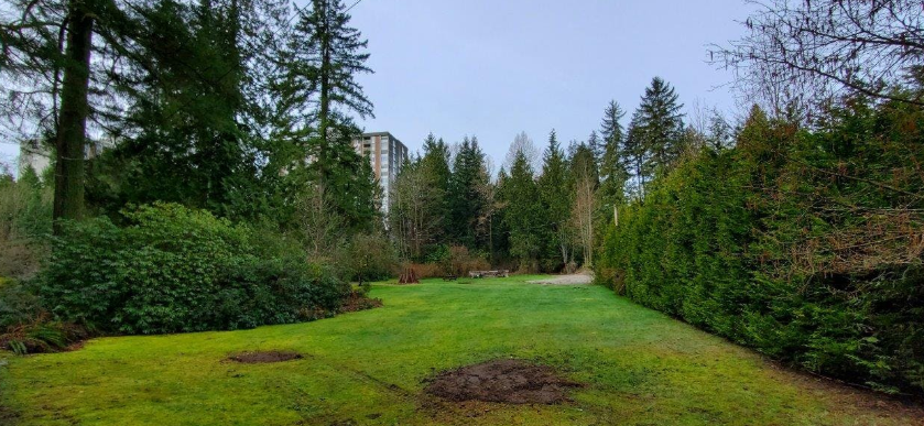
At the heart of this initiative is a bold move to consolidate future growth within Cypress Village—a currently underutilized, forested area zoned for single-family homes—into a dense, walkable neighbourhood with about 3,500 housing units, local shops, community amenities, and transit connections. In exchange, the nearby Eagleridge lands, also zoned for low-density development, will be protected in perpetuity as parkland.

This approach reflects the District of West Vancouver’s 2018 Official Community Plan (OCP), which envisioned compact, sustainable neighbourhoods and large-scale land conservation through a strategy known as “transfer of development potential.” By shifting the right to build from one area (Eagleridge) to another (Cypress Village), the plan maintains a balanced land value equation while steering growth away from environmentally sensitive lands.

From Vision to Reality: A Three-Phase Community Planning Process

The process has unfolded over three phases since 2020, each marked by public engagement, stakeholder input, and evolving plans.

  • Phase 1 (2020) asked residents to weigh in on trade-offs: a smaller development with partial conservation or a larger Cypress Village in return for protecting all of Eagleridge. The community responded clearly—67% of West Vancouver residents supported full protection of Eagleridge.

  • Phase 2 (2021) introduced a detailed land use plan for Cypress Village, including its village core, housing types, public spaces, and environmental protections. Community support continued, though with a wider range of feedback—56% supported the land use plan and 59% the proposed village form and character.

  • Phase 3 (2022) focused on reviewing the draft Area Development Plan and offering final input before the bylaws move forward. Engagement included online forms, Zoom meetings, public booths, and direct mail, with an emphasis on transparency, education, and accountability.

What’s in the Plan? Housing, Nature, Mobility, and More

Cypress Village is set to become a new model for growth on the North Shore. Key features include:

  • A mix of housing: From strata and market rentals to purpose-built affordable rentals and townhomes—offering more variety than West Vancouver’s typical single-family stock.

  • Community infrastructure: A fire hall, community centre, school site, child care, and a sports field are all part of early planning.

  • Sustainable transportation: A pedestrian-friendly core, cycling infrastructure, and an Independent Transit Service with plans for future TransLink integration.

  • Environmental protection: 100% of Eagleridge lands owned by British Pacific Properties (BPP) will be transferred to the District as parkland. Development setbacks, like a 39-metre buffer along Cypress Creek, are built into the plan to protect sensitive ecosystems.

The Phased Development Agreement (PDA) outlines how and when amenities and housing will be delivered, ensuring the community is built out thoughtfully over the next 20–25 years.

Addressing Community Concerns

Throughout the engagement process, the District received and responded to hundreds of questions and suggestions. Concerns about traffic impacts, stormwater management, wildfire risk, school capacity, and impact on local wildlife were addressed in detailed technical studies and policy revisions.

The plan also reflects evolving local values around recreation (mountain biking, bouldering), cultural recognition (Indigenous signage and heritage interpretation), and employment space in the “Benchlands,” designed to support business park uses and potentially new housing.

What’s Next?

The final step is approaching: a formal presentation of the full bylaw package to Council, followed by a public hearing. The package includes the final Area Development Plan, zoning amendments, the Phased Development Agreement with BPP, and supporting documents.

If adopted, Cypress Village will become one of the most significant community-building projects in West Vancouver’s history, helping the District meet housing goals while preserving the natural landscapes that define its character.


Curious how Cypress Village could reshape the future of the Upper Lands? Projects like this are redefining sustainable growth on the North Shore. Want to stay in the loop—or be part of the conversation? We’re keeping a close watch on what comes next.

Read

Revitalizing Klee Wyck Park: West Vancouver’s Historic Gem Set for Community-Centered Renewal

Klee Wyck Park in West Vancouver is on the cusp of a thoughtful transformation. Rooted in deep heritage and a history of public service, the 6.2-acre site in the Cedardale neighbourhood is being reimagined as a revitalized community park shaped by local voices. Recent demolition, design studies, and broad community consultation have laid the groundwork for a new chapter in the park’s legacy — one that honors its past while prioritizing inclusivity, recreation, and natural beauty.


A Legacy of Giving and Greenery

Located at 200 Keith Road near the Capilano River, Klee Wyck Park has long held significance in West Vancouver — not just for its lush, rustic estate landscape, but for the story behind it. The property was the longtime home of Dr. Ethlyn Trapp, a pioneering cancer researcher and humanitarian who lived there from 1942 until her passing in 1972. She named it “Klee Wyck” after her friend, artist Emily Carr, borrowing the nickname given to Carr by an Indigenous community — meaning “laughing one.”

In 1960, Dr. Trapp gifted the estate to the District of West Vancouver with a binding agreement: the land must be used only for recreation, gardening, or other community purposes, and the name Klee Wyck must remain. That vision endured for decades, with the property serving as a site for arts and culture programming and nursery operations.

However, the house and surrounding structures fell into disrepair after years of underinvestment. By 2018, structural assessments confirmed they were beyond their useful life, with asbestos and mold posing significant safety concerns. In 2021, the District demolished the house, studio, and greenhouses, and began restoring the landscape — clearing invasive plants and reopening the park’s scenic vistas.


Reimagining the Park: What’s on the Table

Now, guided by both history and public input, the District of West Vancouver is exploring a range of improvements designed to enhance Klee Wyck Park’s community value while honoring Dr. Trapp’s original intent.

1. Community Gardens and Outdoor Learning Spaces
A consistent theme in public engagement was strong support for community gardens, tying back to Dr. Trapp’s original gift and the site’s legacy as a plant nursery. There’s also interest in integrating an outdoor classroom or covered shelter for educational programming and community gatherings.

2. Trails, Gardens, and Heritage Landscaping
Proposals include weaving new trails through "garden rooms" — landscaped pockets of native and introduced plants, possibly featuring public art or interpretive signs. There’s an emphasis on accessibility, with gravel and asphalt paths connecting to the Capilano Pacific Trail where feasible. Restoring and enhancing historic rhododendron and azalea gardens is also a top priority.

3. Amenities for All Ages
Residents voiced support for a variety of features: a picnic shelter, children’s play areas, sports courts (especially pickleball), a viewing deck near the river, and even a fenced off-leash dog area. Many of these elements would be designed with low operational costs and Crime Prevention Through Environmental Design (CPTED) principles in mind.

4. Gatehouse: Restore or Retire?
The small gatehouse, the only structure left standing, remains a point of debate. While surveys suggest potential uses like storage, a meeting space, or even a washroom, in-person engagement showed little community interest in preserving it. If it stays, options include assigning it to a community gardens group or even a caretaker role.

5. Access, Parking, and Circulation
With current access via a narrow driveway, the District is studying options for a wider, more visible entrance off Keith Road. A small parking lot within the park may help reduce street congestion. The goal is to create better sight lines and encourage foot and bicycle traffic, with potential storage for bikes also in the plan.


Listening to the Community

The public engagement process — held from April to May 2022 — drew hundreds of interactions through surveys, virtual meetings, and pop-up events in the park. Survey results showed high value placed on picnic areas, washrooms, and community gardens. Feedback also underscored the importance of accessibility, Indigenous heritage representation, and thoughtful, low-impact development.

Despite occasional concerns about cost and maintenance, many residents expressed enthusiasm for turning Klee Wyck into a vibrant, multi-use space — a place where beauty, history, and recreation can flourish side by side.


What’s Next?

The District is now synthesizing the input into a set of guiding principles and key design objectives. These will shape the next stages of planning and cost estimation, before being presented to Council for direction. Volunteer opportunities, such as invasive plant removal or future community gardening, are expected to follow in phased rollouts.

The District’s ongoing commitment to preserving Dr. Trapp’s vision — while adapting the park to modern community needs — positions Klee Wyck to become a standout example of how public spaces can grow with their neighbourhoods.


Curious how the Klee Wyck transformation could impact life in Cedardale or connect you more deeply to West Vancouver’s green spaces? We’re tracking updates closely to keep our clients informed and inspired. Want to stay in the loop?

Read