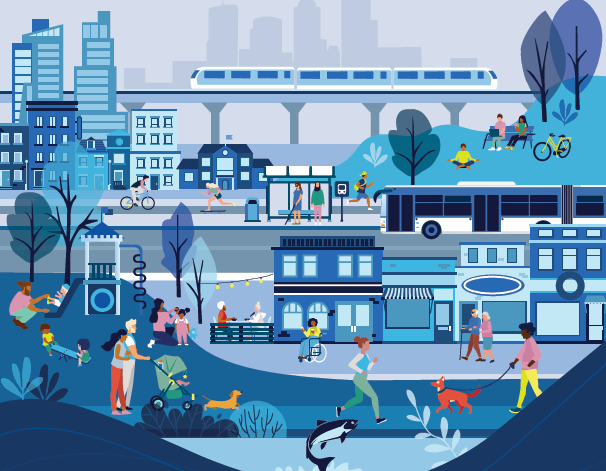
The landscape around Vancouver’s Rupert and Renfrew SkyTrain stations is poised for a major transformation. With the City of Vancouver now in the final planning stages, the Rupert and Renfrew Station Area Plan outlines an ambitious 30-year vision to guide growth, housing, transportation, and job creation in this key East Vancouver corridor. Tied closely to the broader Vancouver Plan (2022), this local strategy aims to reshape how residents live, work, and move through the neighbourhood—while acknowledging its deep Indigenous roots.
A Future Shaped by Reconciliation, Resilience, and Density
Collaboration with Host Nations
A central pillar of the plan is reconciliation with the xʷməθkʷəy̓əm (Musqueam), Sḵwx̱wú7mesh (Squamish), and səlilwətaɬ (Tsleil-Waututh) Nations. Their presence is not only acknowledged in ceremonial terms, but is materially integrated into redevelopment efforts. A standout example is the transformation of 3200 East Broadway—the former Liquor Distribution Centre—into a landmark mixed-use development led by the Nations. This site sits at the heart of the Plan Area and will offer homes, employment space, public amenities, and culturally grounded design.
Environmental Renewal Through Still Creek
Still Creek, an ecological gem buried for decades under industrial and urban growth, will be revitalized through “daylighting”—a process of uncovering and restoring streams. The plan includes ecological corridors, trails, and natural green spaces to reconnect people and wildlife with this historic waterway. With overwhelming public support (94.2% in favour), enhancements to Still Creek are seen as a catalyst for restoring biodiversity and reducing flood risk.
High-Rises, Missing Middle, and New Villages: Housing for All
Transit-Oriented Density Around Stations
In the area closest to Rupert and Renfrew stations, expect dramatic changes to the skyline. High-rise buildings—ranging from 29 to 45 storeys—are proposed for these “Station Areas,” supported by an expanded retail and services base. New buildings will be shaped by housing tenure, with incentives for market rental, below-market rental, and social housing units. Public feedback reveals strong support for density near transit, especially if affordability and infrastructure keep pace.
Complete Communities in Villages and Multiplex Zones
Beyond the towers, the plan proposes a patchwork of mid-rise “villages” (up to 6 storeys) and “multiplex” zones (3–4 storeys) to create walkable neighbourhoods with shops, services, and community amenities. These areas aim to welcome families and middle-income earners through expanded housing options. However, some residents expressed concerns over affordability and neighbourhood character, especially where height and scale could disrupt the existing fabric.
Twelve ‘Unique Sites’ for Special Treatment
Several notable locations, including Frog Hollow and the Italian Cultural Centre, are earmarked for tailored development strategies. These sites will mix residential, cultural, and public realm enhancements to reflect their heritage and community importance.
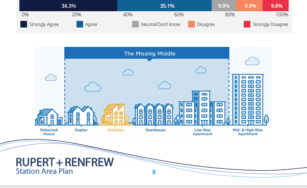
*Photo by City of Vancouver
A Plan for Jobs and Business Growth
Employment Lands Reinforced, Not Replaced
Rather than opening employment lands to housing—a move opposed by city policy—the plan envisions denser job spaces near transit hubs. Think taller buildings for light industrial, retail, office, and even artist studios. While some respondents pushed for more residential in these areas, the city remains firm: the area’s commercial base must remain intact to support future job growth.
Big box retail along Grandview Highway will stay—but with a future-oriented twist. Mixed-use redevelopment (e.g., residential atop retail) may be encouraged, while pedestrian and cycling infrastructure will make these shopping areas more accessible and community-friendly.
Greener, Safer, More Connected Streets
A 25-Year Public Realm Strategy
The updated plan doesn’t just build up—it opens space for people. A new Public Realm Strategy outlines a long-term vision to transform roads, plazas, and underutilized corners into vibrant public places. The goal: make it easier to walk, bike, and roll across the neighbourhood while integrating greenspaces, rain gardens, and tree-lined corridors.
Proposed greenways and improvements to pedestrian safety reflect community desires for quieter, people-first streets, even as the area densifies. Concerns about traffic congestion and parking were noted, but so was strong support (over 88%) for the plan’s transportation upgrades.
Next Steps: What’s Coming in 2025
Now in its final phase, the Rupert and Renfrew Station Area Plan is being refined based on technical and economic analysis, as well as robust public feedback. Updates to land use, density, and public space strategy have already been made. The Final Plan is expected to go to Vancouver City Council in Summer 2025 for debate and decision.
If approved, the area’s transformation will unfold gradually over decades—marking one of the most significant planning efforts in East Vancouver in recent memory.
Curious how this could shape the future of East Vancouver? We’re tracking projects like the Rupert and Renfrew Station Area Plan closely to help our clients stay informed and ahead of the curve. Want to be one of them?
Comments:
Post Your Comment: