A 7-kilometre greenway linking downtown Vancouver to its eastern boundary is in the works — and it promises to reshape how residents and visitors move, connect, and enjoy the city’s industrial waterfront. The Portside Greenway will run from Gastown to Boundary Road, creating a continuous All Ages and Abilities (AAA) active transportation corridor that prioritizes walking, cycling, and rolling in a safer, more scenic environment.
Let’s dive into what’s planned, what’s at stake, and how this project could reimagine life along Vancouver’s northern edge.
A Modern Waterfront Route for All
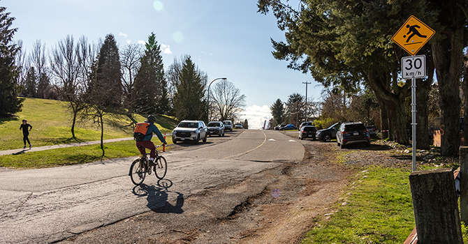
The Portside Greenway follows the rugged industrial coastline of Burrard Inlet — a corridor long identified in city plans as a prime opportunity for green space and active transportation. While parts of the route are already in use by cyclists, the project will formally upgrade and unite four distinct segments — Alexander, Powell, Wall Street, and Bridgeway — into a continuous car-light or car-free path suitable for people of all ages and abilities.
From Alexander Street in historic Gastown to Boundary Road near the Burnaby border, the greenway aims to become a high-quality public space. It’s not just about getting from A to B — it’s about making that journey inviting, safe, and connected to the city’s parks, neighbourhoods, and waterfront views.
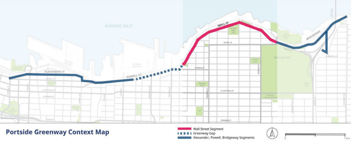
*Photo by City of Vancouver
What’s Driving the Project?
The vision for the Portside Greenway isn’t new. It traces its roots back to the 1928 Bartholomew Plan and was formally endorsed through the Vancouver Greenways Plan (1995), the Transportation 2040 Plan, and most recently, the Vancouver Plan (2022).
The project aligns with several civic priorities, including:
Equity in transportation by providing accessible, safe options across diverse communities.
Climate action by encouraging low-carbon travel.
Urban livability through expanded green public spaces.
Greenways, defined as pathways for pedestrians and cyclists that often incorporate nature and local culture, are designed to reconnect urban residents with their city’s landscapes — and the Portside Greenway does just that.
A Closer Look: The Wall Street Segment
Each section of the greenway presents unique challenges. Nowhere is that more evident than on Wall Street, east of Victoria Drive — a residential corridor with postcard-worthy views and street-end parks, but also high traffic volumes and gaps in pedestrian infrastructure.
In response to safety concerns raised during Phase 1 public engagement in Spring 2023, city staff developed two options for this stretch:
Car-Light Street Option
This approach proposes transforming Wall Street into a quieter, shared two-way street. Traffic would be calmed through diversions and closures, allowing for sidewalks, new street trees, and better pedestrian access without fully removing vehicles.Protected Bike Lane Option
This design maintains two-way vehicle traffic but adds a physically protected bike lane. It prioritizes separation of cyclists from cars, keeping parking on one side, though with less room for greenery and sidewalk expansion.
A second round of public input in Fall 2024 focused specifically on these options. That phase is now closed, with feedback under review and a summary expected in Spring 2025. A refined preferred design will be shared later this year during Phase 3 engagement.
What's Happening with the Other Segments?
While Wall Street gets the bulk of attention for now, the city is quietly advancing plans for the other sections:
Powell Street Segment is under active study, particularly regarding transit routes, business access, and delivery logistics. It ties closely to the Gastown Public Space Plan and efforts to improve bus performance.
Alexander and Bridgeway Segments are being explored for “quick wins” — simpler improvements that can be implemented quickly following community consultation.
Longer-term construction, particularly for the Wall Street segment, is anticipated to begin in 2026 or 2027, aligned with planned sewer upgrades.
Partnerships and Place-Making
The Portside Greenway isn't just about pathways — it's about partnerships. The City has been working with local Indigenous Nations, including the Sḵwx̱wú7mesh (Squamish) Nation, who have expressed interest in native species planting and incorporating Indigenous art and cultural elements throughout the greenway.
This initiative also respects the project’s location on the unceded territories of the Musqueam, Squamish, and Tsleil-Waututh Nations, with continued engagement and updates planned as the project moves forward.
Greenways Past, Present, and Future
The 1995 Greenways Plan laid the funding foundation, and while the City hasn’t detailed current sources for the Portside Greenway, implementation is expected to span multiple capital plans and be supported by development contributions, civic improvement budgets, and other public-private sources.
In the end, the Portside Greenway will offer more than just a route — it will link key destinations including Maple Tree Square, New Brighton Park, the Wall Street Community Garden, and Hastings Park, strengthening the waterfront’s role as a cultural and recreational spine for East Vancouver.
Curious how this could shape life along Wall Street and beyond? Projects like the Portside Greenway are reshaping how we connect with our city — and we're keeping a close eye on every step forward. Want to stay informed or talk about how this might affect your neighbourhood? Let’s connect.